File:Nseamap.gif
Manghe 'a risoluzione ierta.
Nseamap.gif (280 × 374 pixel, dimenzione d'u fail: 43 KB, tipe de MIME: image/gif)
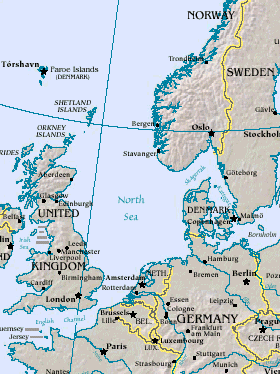
Map of North Sea, from the US Department of Energy: http://eia.doe.gov/emeu/cabs/northsea.html
Русский: Северное море
| This image is a work of a United States Department of Energy (or predecessor organization) employee, taken or made as part of that person's official duties. As a work of the U.S. federal government, the image is in the public domain.
Please note that national laboratories operate under varying licences and some are not free. Check the site policies of any national lab before crediting it with this tag.
|

|
cunde
Cazze sus 'na date/orarie pe vedè 'u fail a cumme asseva jndr'à quidde timbe.
| Sciurne/Orarie | Thumbnail | Dimenziune | Utende | Commende | |
|---|---|---|---|---|---|
| corrende | 16:20, 26 Mar 2005 | | 280 × 374 (43 KB) | Ivan~commonswiki | Map of North Sea, from the en:US Department of Energy: [http://eia.doe.gov/emeu/cabs/northsea.html http://eia.doe.gov/emeu/cabs/northsea.html] {{PD-USGov}} |
Ause d'u file
sta pàgene apponde a stu fail:
Ause d'u file globale
Le seguende Uicchi ausane stu file:
- Ause sus a als.wikipedia.org
- Ause sus a am.wikipedia.org
- Ause sus a ast.wikipedia.org
- Ause sus a as.wikipedia.org
- Ause sus a ban.wikipedia.org
- Ause sus a ba.wikipedia.org
- Ause sus a be-tarask.wikipedia.org
- Ause sus a csb.wikipedia.org
- Ause sus a cv.wikipedia.org
- Ause sus a da.wikipedia.org
- Ause sus a de.wiktionary.org
- Ause sus a diq.wikipedia.org
- Ause sus a en.wikipedia.org
- Ause sus a eo.wikipedia.org
- Ause sus a gl.wikipedia.org
- Ause sus a he.wikipedia.org
- Ause sus a hif.wikipedia.org
- Ause sus a hr.wikipedia.org
- Ause sus a hu.wiktionary.org
- Ause sus a id.wikipedia.org
- Ause sus a is.wikipedia.org
- Ause sus a it.wikipedia.org
- Ause sus a it.wikibooks.org
- Ause sus a ja.wikipedia.org
- Ause sus a jv.wikipedia.org
- Ause sus a ka.wikipedia.org
- Ause sus a kw.wikipedia.org
- Ause sus a lij.wikipedia.org
- Ause sus a lt.wikipedia.org
- Ause sus a ml.wikipedia.org
- Ause sus a mn.wikipedia.org
- Ause sus a mwl.wikipedia.org
- Ause sus a nn.wikipedia.org
- Ause sus a olo.wikipedia.org
- Ause sus a pl.wiktionary.org
- Ause sus a pt.wikipedia.org
- Ause sus a ru.wikipedia.org
- Ause sus a ru.wiktionary.org
- Ause sus a sah.wikipedia.org
- Ause sus a sco.wikipedia.org
- Ause sus a simple.wikipedia.org
Vide ause globale de stu file.