File:Caspian Sea from orbit.jpg

File origgenale (4 400 × 5 600 pixel, dimenzione d'u fail: 3,44 MB, tipe de MIME: image/jpeg)
Riepileghe
| Descrizione |
العربية: منظرٌ من مدار الأرض لِبحر قزوين. التعليق الأصلي: كما أوردته وكالة الناسا: ::"القسم الشمالي من بحر قزوين يُعاني من ظاهرةٍ تُعرف باسم التخثث أو إغناء الماء، وهي تلك الحالة التي تتسببُ فيها الأسمدة الزراعيَّة المُنسابة من خِلال مياه الري والأمطار بِنُمو الطحالب في المياه. يُؤدي نُفوق وتحلُّل تلك الطحالب إلى حرمان المياه من الأكسجين، ممَّا يُؤدي بِدوره إلى الإضرار بِالحياة البريَّة بِطبيعة الحال. هذه الصُورة لِبحر قزوين تُظهرُ بعض الدوَّامات الخضراء والزرقاء على مقرُبةٍ من مصب نهر الڤولغا (أعلى الوسط)، ممَّا يدُل على وُجود كميَّةٍ من الطحالب. اللون الأزرق اللامع في القسم الشمالي الشرقي من البحر قد يكون تولَّد نتيجة اختلاط بعض النباتات بِالترسُبات، نظرًا لِأنَّ هذا الموقع هو أكثر المناطق ضُحولةً في البحر.
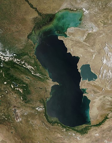
English: This is a view from orbit of the Caspian Sea as imaged by the MODIS sensor on the Terra satellite. Caption: The original caption from NASA: ::"The northern part of the Caspian Sea is plagued by a process called eutrophication, in which agricultural run-off rich in fertilizers stimulates rampant growth of algae in the water. The death and decay of these algae robs the water of oxygen, with obvious negative consequences for aquatic life. This image of the Caspian Sea shows swirls of green and blue near the mouth of the Volga River (top center), which indicate the presence of algae. The bright blue color of the northeastern part of the sea may be due to a mixture of plant life and sediment, for this is where the sea is most shallow. This image is from the Moderate Resolution Imaging Spectroradiometer (MODIS) on the Terra satellite on June 11, 2003.
Español: El Mar Caspio visto desde la órbita terrestre
فارسی: تصویر ماهوارهای از دریای خزر
Тоҷикӣ: Тасвири Баҳр Каспӣ аз осмон |
| Date | |
| Sorgende |
http://visibleearth.nasa.gov/view_rec.php?id=5514
|
| Autore | Jeff Schmaltz, MODIS Rapid Response Team, NASA/GSFC |
| Otre versiune | Opere derivate da questo file: Caspian Sea from orbit-NoRedLines.jpg |
|

|
Questa immagine è stata valutata secondo i criteri per le immagini di valore ed è considerata l'immagine di maggior valore su Commons per l'argomento: Satellite images of the Caspian Sea. Puoi vedere la sua valutazione qui. |
Licenziate da
| Questo file è nel pubblico dominio perché creato dalla NASA. La politica sul copyright della NASA afferma che «il materiale della NASA non è protetto da copyright a meno che non sia specificato altrimenti». (NASA copyright policy e JPL Image Use Policy). | ||
 |
Attenzione:
|
cunde
Cazze sus 'na date/orarie pe vedè 'u fail a cumme asseva jndr'à quidde timbe.
| Sciurne/Orarie | Thumbnail | Dimenziune | Utende | Commende | |
|---|---|---|---|---|---|
| corrende | 11:16, 14 Sci 2010 | | 4 400 × 5 600 (3,44 MB) | Originalwana | higher res |
| 17:10, 8 Feb 2005 |  | 550 × 700 (67 KB) | Pixeltoo | Caspian sea by space Nasa |
Ause d'u file
sta pàgene apponde a stu fail:
Ause d'u file globale
Le seguende Uicchi ausane stu file:
- Ause sus a af.wikipedia.org
- Ause sus a als.wikipedia.org
- Ause sus a am.wikipedia.org
- Ause sus a ang.wikipedia.org
- Ause sus a an.wikipedia.org
- Ause sus a arc.wikipedia.org
- Ause sus a ar.wikipedia.org
- بحر قزوين
- ويكيبيديا:صور مختارة/الفضاء والكون/نظرة إلى الخلف
- ويكيبيديا:ترشيحات الصور المختارة/بحر قزوين
- ويكيبيديا:صورة اليوم المختارة/ديسمبر 2016
- قالب:صورة اليوم المختارة/2016-12-23
- مستخدم:قائمة أكبر البحيرات والبحار في المجموعة الشمسية
- ويكيبيديا:صورة اليوم المختارة/يوليو 2020
- قالب:صورة اليوم المختارة/2020-07-16
- ويكيبيديا:صورة اليوم المختارة/يوليو 2023
- قالب:صورة اليوم المختارة/2023-07-26
- Ause sus a arz.wikipedia.org
- Ause sus a ast.wikipedia.org
- Ause sus a as.wikipedia.org
- Ause sus a av.wikipedia.org
- Ause sus a azb.wikipedia.org
- Ause sus a az.wikipedia.org
- Ause sus a bat-smg.wikipedia.org
- Ause sus a be.wikipedia.org
- Ause sus a bg.wikipedia.org
- Ause sus a bh.wikipedia.org
- Ause sus a bn.wikipedia.org
- Ause sus a br.wikipedia.org
- Ause sus a bs.wikipedia.org
- Ause sus a bxr.wikipedia.org
- Ause sus a ca.wikipedia.org
- Ause sus a ce.wikipedia.org
- Ause sus a ckb.wikipedia.org
- Ause sus a co.wikipedia.org
- Ause sus a cs.wikipedia.org
Vide ause globale de stu file.